
Microzonation and Study of Jakarta Sedimentary Basin for Earthquake Hazard Mitigation
HEAD OF TEAM : Prof. Sri Widiyantoro, Ph.D.
TEAM MEMBERS : Rexha Verdhora Ry, M.T., Dr. Tedi Yudistira, Dr. Andri Dian Nugraha
OFFICIAL ADDRESS : Jurusan Teknik Geofisika, ITB Bandung, Jalan Ganesha 10 Bandung
Introduction
Improving earthquakes risk assessment in populated cities is crucial considering the global growth of population and infrastructure. Learning from countless catastrophic earthquakes in the last decades, the near-surface geology could influence the damaging impact at a site, so-called by site effects. While geological structures and faults mapping are required in analyzing seismicity hazard around cities, the evaluation of near-surface geology and site effects within the cities has become more urgent recently. This evaluation could be conducted by profiling shear-wave velocity (Vs) of sedimentary deposits down to bedrock.
Recently, Park and Ishii [1] introduce an alternative approach for estimating near-surface wave velocity (representing apparent seismic velocity from a surface to shallow depth) by taking benefits of body-wave polarization. It is possible to estimate Vs and Vp at near-surface by observing the polarization directions of P-waves and S-waves generated by earthquakes at a seismic station. Besides that it does not require any artificial sources or other expensive equipment, it can be applied with low-computation efforts. Applicable to urban areas, we apply this technique to map shallow Vs beneath Jakarta, the capital city of Indonesia. Lying on a thick young sedimentary basin as emphasized in several studies [2]–[5], Jakarta possesses high seismic risk due to site effect.
Method
Park and Ishii [1] emphasize a relationship between the seismic waves velocity and the polarization of body waves on the free surface. In the time that a body wave arrives at Earth’s free surface, the incident wave is then both reflected and converted. In particular, the incident P-wave generates a reflected P-wave and a converted SV wave. This yields the particle motion of P-waves recorded by a three-component seismometer on the free surface as the combination of the incoming and the two outgoing waves, which is defined by the apparent incidence angle. The incoming polarization directions of P-waves are susceptive to Vs. Meanwhile, similar to that combination, those of S-waves are susceptive to both Vs and compressional-wave velocity (Vp).
Data
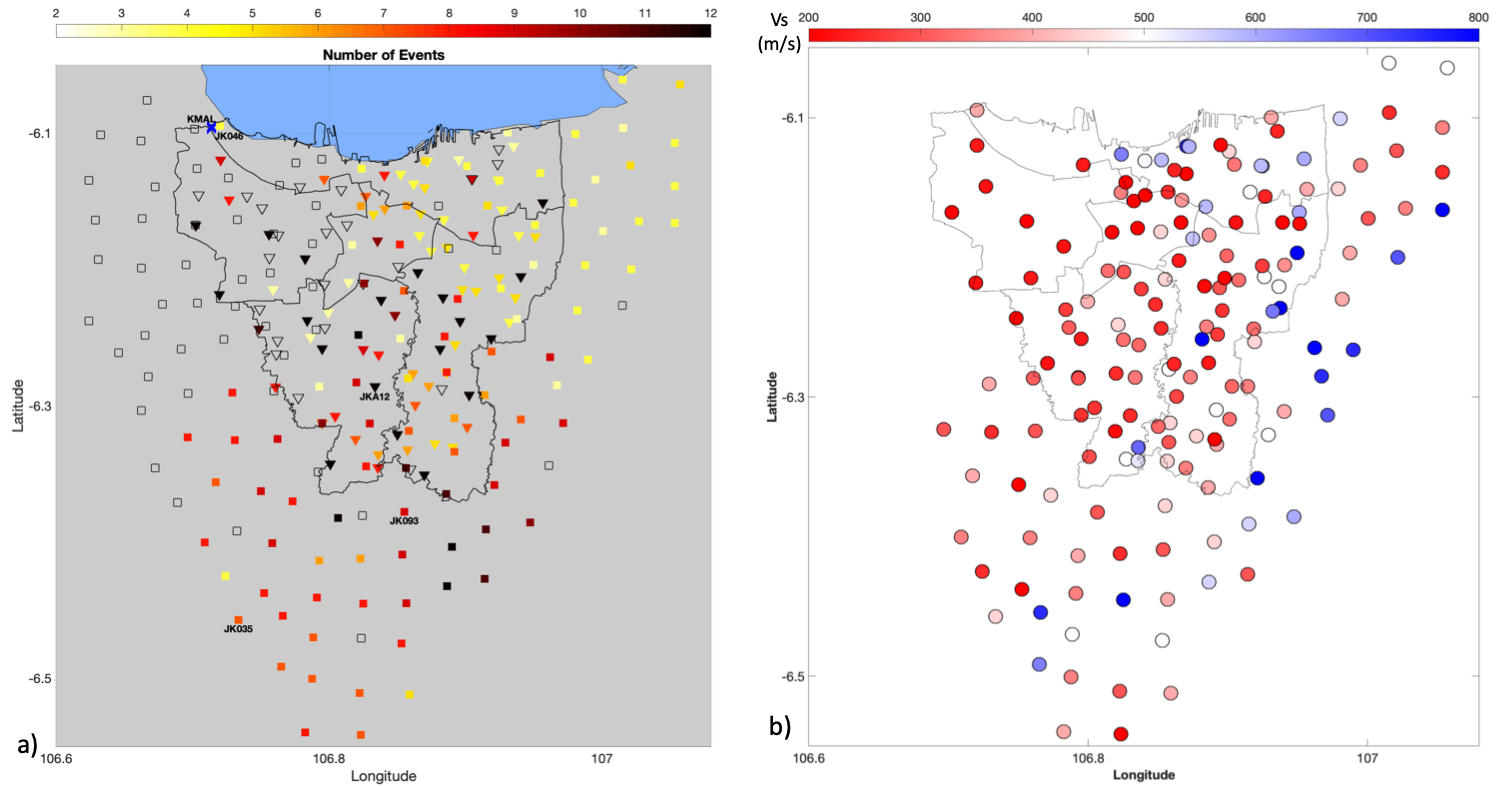
Three-component broad-band seismometers of Trillium Compact 20s and digitizers built by the Australian National University were installed at different sites (Figure 1a), divided into two seismic networks. Stations were deployed temporarily in schools, on a concrete paving floor, throughout the city with a spacing of 3-5 km. The first seismic network was operated from October 2013 to February 2014 covering the most area of Jakarta. The 26 stations were maintained for 3-months of recording as semi-permanent stations and the other 26 stations were redeployed in three phases with each of one-month duration. Meanwhile, the second seismic network deployed in 2018 aims mostly to cover the outer part of Jakarta in revealing the extending basin edges. The 30 stations were maintained and redeployed in five phases with at least one-month duration for every site.
Results and Discussion
The shear-wave velocities range from 200 to 800 m/s (Figure 1b). Within the boundary of Jakarta, its most area is dominated by low Vs between 200 and 400 m/s. The area given by low Vs extends out from the city mainly to the west-southern part. On the contrary, the eastern part of the city boundary mostly highlights higher Vs, especially the outer area. Moreover, and also unexpectedly, higher Vs can be observed at the northern part very near to the coastline. These all features relate to sedimentary deposits and their edges to bedrock beneath the study area. Park and Ishii [1] suggest that the shear-wave velocities they obtained associate to depths of 100 meter or less than a kilometer.
The distribution of low Vs shows that sedimentary deposits comprise almost all area of Jakarta’s surface geology. Although the contrast between Holocene and Pleistocene deposits is insignificant and their boundary is indistinguishable from this result, their deposits obviously fill the Jakarta basin through the depth of at least 100 m. These deposits reach the outer part of Jakarta administrative margin mostly to the west-southern part, more than 10 km away. The result is in accordance with Cipta et al. [6] who report the estimation of basin extension based on arc method. Unfortunately, the western part is still not completely revealed in this study.
Considering the sedimentary deposits overwhelming Jakarta and its vicinity, the following studies of site amplification would be prominent. The reliable information of the Jakarta basin depth and edges is immensely required. Despite its edges at the eastern part is probably revealed in this study, the complete structure remains a question for further studies.

Figure 1. (a) Map of the seismic networks around Jakarta city. The reverse triangles represent the seismic network operated between October 2013 and February 2014. The squares represent the seismic network operated between April 2018 and October 2018. (b) Map of near-surface shear-wave velocities represented by colored circles. Red is low and blue is high.
Conclusion
The shallow part of the Jakarta basin is revealed, while sediments cover most area of the city. Improving earthquakes risk assessment in the city becomes more crucial, while for future studies, it can be extended to obtain a complete geometry of Jakarta sedimentary basin and conduction a ground-motion simulation. Nevertheless, similar issues may exist in other populated cities, especially in Indonesia. This technique may help identify and map near-surface structures which usually lack, with low-computation cost wherever three-component seismometers are deployed.
References
- S. Park and M. Ishii, “Near-surface compressional and shear wave speeds constrained by body-wave polarization analysis,” Geophys. J. Int., vol. 213, no. 3, pp. 1559–1571, 2018.
- R. F. Lubis, Y. Sakura, and R. Delinom, “Groundwater recharge and discharge processes in the Jakarta groundwater basin, Indonesia,” Hydrogeol. J., vol. 16, no. 5, pp. 927–938, 2008.
- M. Ridwan, S. Widiyantoro, M. Irsyam, Afnimar, and H. Yamanaka, “Development of an engineering bedrock map beneath Jakarta based on microtremor array measurements,” Geohazards Indones., pp. 153–165, 2016.
- E. Saygin et al., “Imaging architecture of the Jakarta Basin, Indonesia with transdimensional inversion of seismic noise,” Geophys. J. Int., vol. 204, no. 2, pp. 918–931, 2016.
- A. Cipta et al., “Seismic Velocity Structure of the Jakarta Basin, Indonesia, using Trans-dimensional Bayesian Inversion of Horizontal-to-Vertical Spectral Ratios,” Geophys. J. Int., pp. 431–449, 2018.
- A. Cipta, P. Cummins, M. Irsyam, and S. Hidayati, “Basin Resonance and Seismic Hazard in Jakarta, Indonesia,” Geosciences, vol. 8, no. 4, p. 128, 2018.