
Fault source of the 2 September 2009 Mw 6.8 Tasikmalaya intraslab earthquake, Indonesia: Analysis from GPS data inversion, tsunami height simulation, and stress transfer
Endra Gunawan [a], Sri Widiyantoro [a], Gayatri Indah Marliyani [b], Euis Sunarti [c], Rachmah Ida [d], Aditya Riadi Gusman [e]
[a] Global Geophysics Research Group, Faculty of Mining and Petroleum Engineering, Bandung Institute of Technology, Indonesia
[b] Geological Engineering Department, Faculty of Engineering, Gadjah Mada University, Indonesia
[c] Faculty of Human Ecology, Bogor Agricultural University, Indonesia
[d] Faculty of Social Sciences and Political Sciences, Airlangga University, Indonesia
[e] GNS Science, Lower Hutt, New Zealand
https://doi.org/10.1016/j.pepi.2019.04.004
Abstract
We estimate the fault model of the 2 September 2009 Tasikmalaya intraslab earthquake based on the GPS data available in western Java, Indonesia. The focal mechanism of the earthquake was used to help construct two possible fault models: a west-dipping fault with a strike of 160.8° and an east-dipping fault with a strike of 34.0°. In this study, vertical information from GPS data is crucial for constructing the top depth of the fault. The subsidence information from GPS data located near the epicenter suggests that the earthquake involved a deeper fault model. While the amount of the moment release of the east-dipping fault (Model dipE) is equivalent to Mw 6.9, the moment release of the west-dipping fault (Model dipW) is equivalent to Mw 6.8. The GPS data inversion indicates that Model dipW produces a better fit than Model dipE. The tsunami simulation indicates that the tsunami height generated by the east-dipping fault is smaller than that generated by the west-dipping fault, implying that the maximum tsunami height of the latter is closer to agreement with the reported one. Unlike Model dipE, the stress transfer analysis of Model dipW indicates that most of the aftershocks were located in the region where ΔCFF is positive, suggesting positive stress from the ruptured triggered aftershocks. The combined analysis of GPS data, tsunami simulation, and stress transfer suggests that the fault ruptured during the 2009 earthquake was dipping westward with a steep dip angle.
Keywords
Coseismic slip; Intraslab earthquake; GPS data; Tsunami simulation; Stress transfer
Introduction
During the past decade, megathrust earthquakes with magnitudes ≥ 7 have occurred along the Sunda trench in western Sumatra. These events were the 2004 Mw 9.2 Sumatra-Andaman and 2005 Mw 8.7 Nias earthquakes in northern Sumatra (e.g. Banerjee et al., 2007) as well as the 2007 Mw 8.4 Bengkulu and 2010 Mw 7.8 Mentawai earthquakes in central Sumatra (Gusman et al., 2010). Along the Sunda trench in southern Java, however, only the 2006 Mw 7.8 Java tsunami earthquake occurred and recorded in the past decade (Ammon et al., 2006; Gunawan et al., 2017).
The 2006 Java tsunami earthquake occurred off the south coast of western Java followed by large tsunami resulted in ~600 deaths and ~75,000 people displaced from their home (Mori et al., 2007). The 2006 Java tsunami earthquake involved a fault rupture with length of ~200 km (Fujii and Satake, 2006), with the western region from the fault identified as coupled and potentially triggered a Mw 8.7 earthquake (Hanifa et al., 2014). At a ~150 km distance to the north from the epicenter of the 2006 Java tsunami earthquake, occurred a destructive earthquake named as the 2 September 2009 Tasikmalaya intraslab earthquake (TIE). The Indonesian National Board for Disaster Management reported that >80 people death with another 188,000 displaced from their homes due to the 2009 TIE.
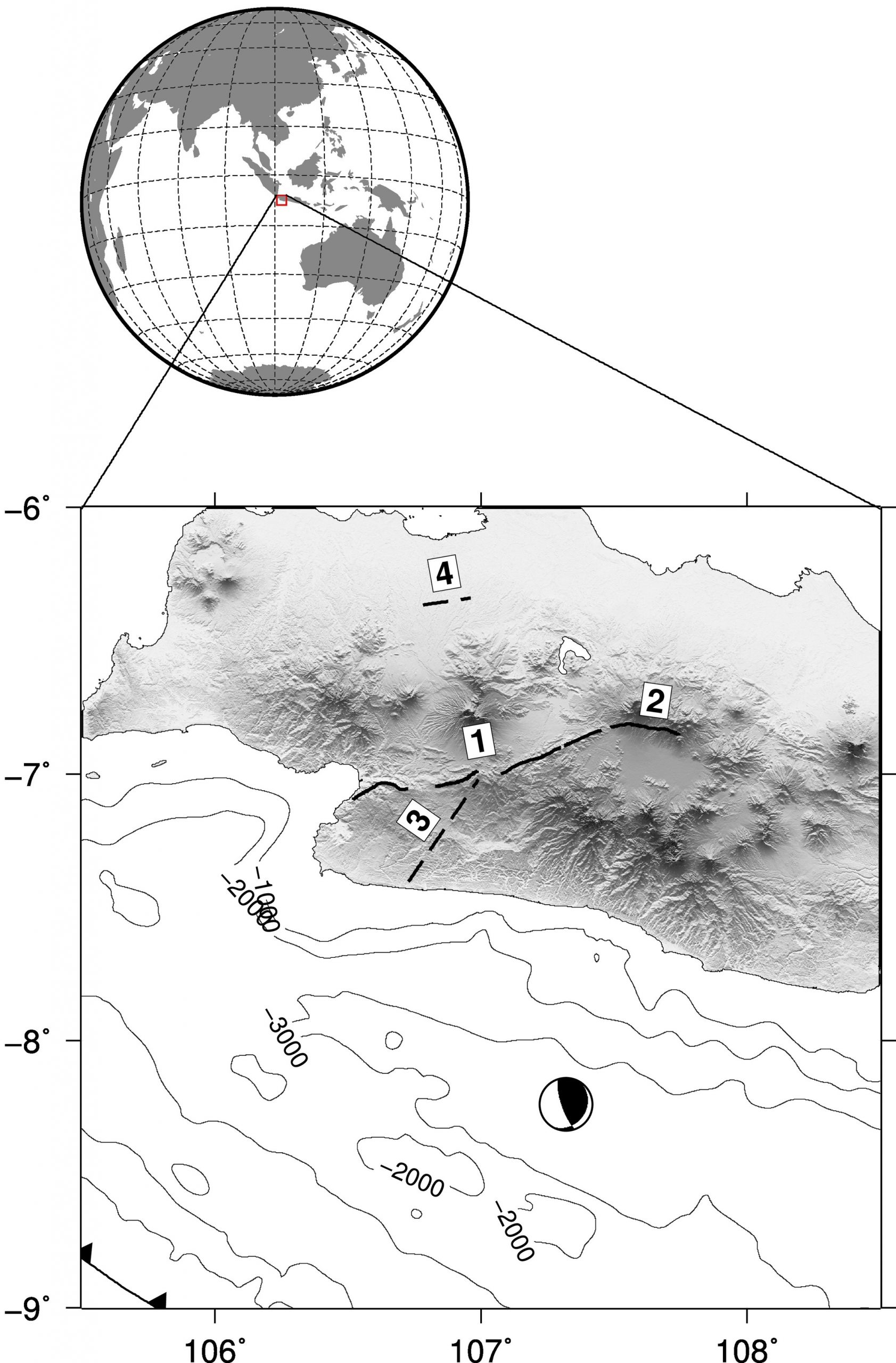
The 2009 TIE occurred at ~200 km to the north of the tectonically active Sunda trench in western Java (Fig. 1), where this subduction zone represents the tectonic boundary between the Indo-Australian plate to the south and the Sundaland block to the north (e.g. Schlüter et al., 2002). Using regional broadband seismometer data, Suardi et al. (2014a) estimated the focal mechanism of the 2009 TIE and suggested a west-dipping fault model with a strike of 160.8°, a dip of 75.3°, and a rake of 71.3° as well as an east-dipping fault model with a strike of 34.0°, a dip of 24.0°, and a rake of 140.7°. This suggests that the dip angle of the westward fault is much higher than that of the plate interface model (Hayes et al., 2012). Moreover, the United States Geological Survey reported that the hypocenter depth is 46 km, which is deeper than the plate interface. This seismological analysis suggests that the TIE was an intraslab earthquake.
Fig. 1. Tectonic setting of our study area. Previously identified crustal faults in western Java are shown by solid lines: (1) Cimandiri fault (Marliyani et al., 2016) and (2) Lembang fault (Afnimar and Rasmid, 2015). Newly identified faults, named as (3) Cipamingkis fault and (4) Jakarta fault, proposed by Gunawan and Widiyantoro (2019), shown by dashed lines. Focal mechanism of the 2009 TIE was taken from Suardi et al. (2014a). Topography and bathymetry contour every 1000 m derived from SRTM (Jarvis et al., 2008) and ETOPO 1 (Amante and Eakins, 2009). Inset shows the global map.
Suardi et al. (2014b) estimated the coseismic slip of the 2009 TIE using seismic data by assuming that the second nodal plane, that is the east-dipping fault, is a fault where the earthquake occurred. In this study, we use the available Global Positioning System (GPS) data in western Java (Hanifa et al., 2014) to analyze the associated fault source of the 2009 TIE by incorporating information from focal mechanisms. In addition, we estimate the tsunami height of the inferred fault models and the stress transfer of the mainshock related to 3-month aftershock data.